The aim of this project is to take an innovative and explorative approach to understanding of the past in the Balkans by assembling the results of cross-border and diachronic archaeological research with the use of responsive, wide-ranging visualization tools. With his turbulent history, unique geographical and ethnical diversity and intermediary position between central Europe and Mediterranean, the eclectic region of the Balkans represents a true challenge for comprehensive humanistic studies aiming to provide an extensive and holistic.
The basis for the feasibility of the project are the research actions and cooperations of the OeAI Department of Prehistory & WANA Archaeology (former OREA) as one of the very few archaeological institutions worldwide with a strong focus on the prehistory of the Balkan Peninsula. The digital reconstruction of sites and ancient landscapes will combine the results of the achieved archaeological work and employ new datasets from geophysical prospections, field surveys and mapping (GIS) in cross-cultural and diachronic perspective. The interdisciplinary actions will generate large amounts of new and essentially missing data that will uniquely incorporate archaeology, geoscience, cartography and digital visual media.
Altogether 5 key areas are selected representing the broad chronological and cultural framework to reach our aims:
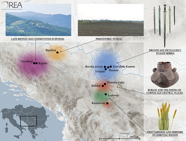
The first topic chosen for the visualization is focusing on the Early Neolithic Period around Leskovac in southern Serbia. Connecting the Mediterranean world (via Vardar-Axios Valley) and the Balkans (south Morava valley) this area is of central importance for the process of the Neolithisation in southeastern and central Europe. New intensive geo-archaeological investigations of the OeAI focus on Early Neolithic sites with the aim to reconstruct paleo-environmental setting and to detect human impact on the landscape during the Holocene. Additional geophysical and geomorphological prospections will clarify extent and structure of settlements. Maps and digital animation will eventually depict the first human colonization and Neolithic surrounding.
The second key study strikingly exemplifies the need and purpose of the visual presentation and preservation since the some of the included archaeological site does not exist anymore physically. The tell-settlement Bubanj near Niš, eponymous for the Copper Age culture in this part of Europe, was devastated already in the early 20th century by the rail section, after that severely bombed in World War II and destroyed in the course of road construction in 1960s. The long-term excavations provided an enormous amount of data regarding architecture and settlement structure (houses, fortifications, and activity zones), material culture and subsistence (botanic and zoological analysis). The detailed digital reconstruction will revive the site, compile the results from previous excavations, and thus elucidate the emergence and development of this extraordinary central place in the Balkans. Included in this part of the project are also contemporary sites Velika Humska Čuka (settlement) and Ranutovac-Meanište (necropolis with cremation burials).
Envisaged for the visualization are sites in eastern Serbia with evidences of the increased copper production and ore exploitation during the Middle and Late Bronze Ages. The key site is Trnjane, situated on a high and unfortified terrace near Bor with copper slag piles (estimated around 20 tons) and belonging urn graveyard. Indications of metallurgical activity were provided also in the recent excavations on the site of Ružana and cremation burials of the same pattern like in Trnjane were documented in nearby Borsko Jezero and Krivaljski Kamen. Thus, the situation in eastern Serbia represents an ideal starting point for the visual presentation of the regional society highly involved in the production of copper, i. e. the community of prehistoric metalworkers and miners.
Another remarkable interaction of landscape and human impact is to observe in the case of the Late Bronze Age occupation of the mountainous area in central part of Bosnia, with hillforts located on dominant strategic position overlooking small river valleys and basins. One striking example is the Zenica Basin along the River Bosna with sites Kopilo and Gradišće, both situated on high plateaus (700 m above sea level). To add are also stone tumuli (diameter between 5 and 15 m), spread along the ridge below Gradišće representing the necropolis of the settlement. This complex of sites in Zenica Basin offers a great opportunity for a generic visual model of the micro-region Bronze Age settlement pattern in the mountain zone of Dinaric Alps.
One of the most fascinating monuments of the Balkan prehistory are Bronze and Iron Age burial tumuli, many of them used as grave places throughout later history and even until recent times. They represent a perfect example of a cross-border cultural heritage in the Balkans that has yet not been properly assessed in terms of visualization and communication. However, a number of tumuli is not visible on the surface due to destruction and only geophysical screening and intensive surveys can detect them. In the frame of the project, we will focus on large earth made tumuli in northeastern Bosnia that represent one of the earliest monuments of this kind in the region.
