In the context of urbanistic studies on Norican towns, the focus is on the presentation and interpretation of the town plan and infrastructure of Flavia Solva as well as the analysis of the diachronic settlement history and fortification of Ovilava.
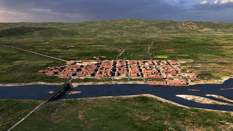
Archaeological research into the Roman ‘capital’ of Styria, Flavia Solva, began around the middle of the 19th century. A new project has attempted to synthesise all the findings and selected finds resulting from excavations and geophysical surveys to date. The results led not only to a complete town plan with the cemeteries, but also to new considerations on the dual diachronic development of the two sites located on the rivers Sulm (Frauenberg/Leibnitz) and Mur (Wagna).
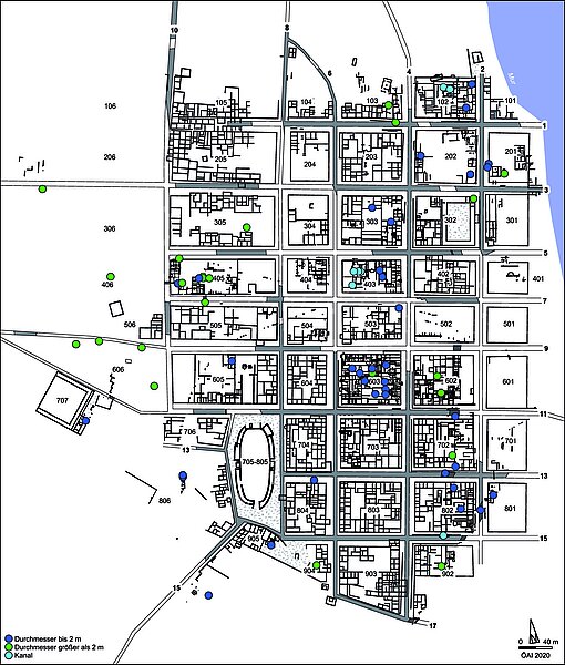
As a starting point, a new plan of the municipium on the Mur with all its insulae and cemeteries is presented, which, based on the total stock of excavation and prospection data up to 2020, allows for the first time the conclusive interpretation of the building patterns and infrastructure. The summarising re-evaluation of all excavation findings provides new evidence for the diachronic development of oppidum and municipium, which is expressed above all in the duality of the two settlement sites, Frauenberg an der Sulm and Wagna an der Mur. Important points of discussion lie not only in the definition of territorial boundaries and interactions with an Alpine imperial patrimony, but also in the rural settlement structures evoked by them.
A period of economic prosperity can be identified in the 2nd century AD, whereby the interdependence of the economic upswing is illustrated by the military development of the Danube Limes. There was a marked slump in urban development, probably caused by Germanic invaders, towards the middle of the 3rd century AD, which was followed by an economic recovery and the importance of Solva in the course of the reorganisation of the province in the Tetrarchic-Constantinian period at the latest. New excavations in the northern suburb bear witness to a complex, over 2,000 m long ditch which, as an irrigated canal, may have provided a short spatial connection between the Sulm and Mur rivers.
In recent years, numerous revealing excavations have taken place in the urban area of Wels, allowing a reassessment of the development of the Roman settlement. As part of a research co-operation with the Stadtmuseum Wels, an exceptional feature with a numerous and highly informative collection of finds is being investigated. This is a ditch complex about 14 m wide, which can be regarded as the oldest late-Antonine fortification of the municipium.
The highly varied assemblage from the backfill of the fossa provides an impressive overview of the utilitarian forms introduced into the north-west region of Noricum as a result of the stationing of Legio II Italica on the River Enns. Around 650 significant vessels of local manufacture are on the one hand very well comparable with the finds from the figlina of Vransko (Slovenia), which was operated by Legio II Italica in the immediate vicinity of the castra of Ločica in the Praetentura Italiae et Alpium on the Amber Road around 170 AD. On the other hand, the best parallels are found in the pottery workshop from the Canabae Northwest of Lauriacum, which was put into operation immediately after the Italic legion was stationed on the River Enns and produced intensively during the 70s/80s of the 2nd century AD. Cross-connections to the territory of Flavia Solva can be established through some individual pieces.

There are numerous small finds made of non-ferrous metal and iron from the Ovilava ditch complex, which can be seen in a direct context with the soldier's everyday life. Militaria and dress items document the wide range of forms common in the environment of Legio II Italica in the late Antonine-early Severan period. As numerous artefacts show, metal processing workshops were located next to the fossa. These may have been working on behalf of the legion in Ovilava, away from the front line of the limes and at the same time on the River Traun, which provided the transport link to the Alpine mining areas in the Salzkammergut region.
since 2020
