The study of the environs of Ephesos is the central focus of the current research project in order to define the catchment area of the city. This applies to both the harbor landscape as well as the agricultural hinterland and the suburbs, i.e. the dense development that grew outside the city walls. Today large swaths of land are privately owned and covered with fruit plantations. As a result the subsoil can only be investigated with special permits.
Since 2008 large scale surveys, architectural documentation, geophysical and geoarchaeological prospections have been carried out. The study draws on a total of about 200 ha of geophysical surveys and over 270 cores. An area of 320,000 m2 has been surveyed and the find material has been quantitatively recorded or collected. Only selective excavations were carried out in order to clarify questions regarding chronology. Simultaneously the archival material was studied in particular historical aerial photographs and illustrations as well as the evaluation of literary sources.
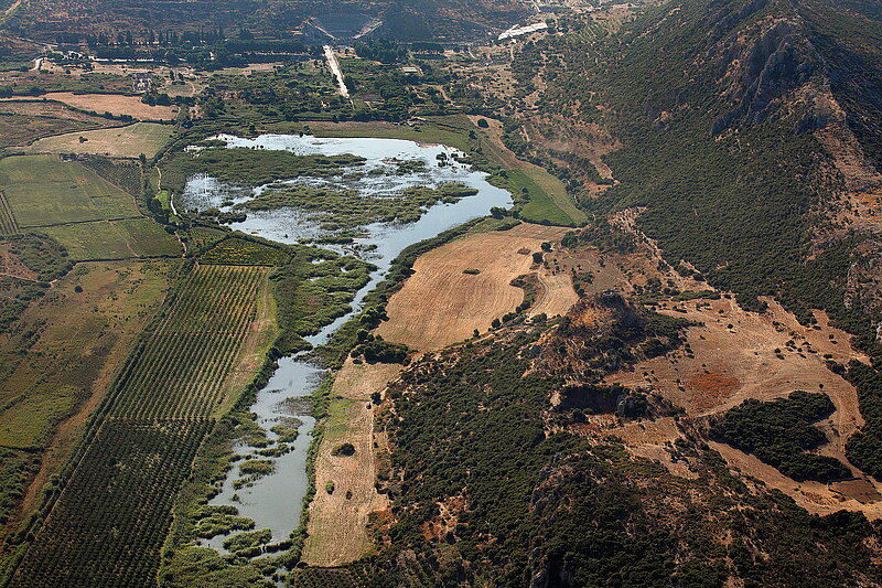
The study of the harbor landscape is essential for the understanding of the city of Ephesos. Over thousands of years of extreme efforts have been made to ensure a direct access to the sea. The canal system was a technical masterpiece that connected the Roman harbor city with the coast and remained in use until late into the Byzantine period.
While the importance of a working harbor for the prosperity of the city was never questioned from the beginning of archaeological investigations in Ephesos, the systematic archaeological investigation only took place in the last several years. This circumstance was due to the complex natural conditions that necessitated an interdisciplinary research approach with the use of the most modern methods and analysis procedures.
At the center of the investigations is the organization of the harbor system of Ephesos that was developed over centuries with a succession of harbors, moorings, canals, and navigation signs. An emphasis has been placed on the structural design of the port itself, particularly the specific installations, infrastructural buildings as well as in their urban connection. Another aspect that needs to be taken into consideration is the economic importance of the city as the most important center for trade between the Mediterranean and Anatolia with a considerable amount of goods transportation that was processed in the harbor where the customs collection took place.
Along the Harbor Channel areas were surveyed that had previously been geophysically surveyed and showed densely built as well as undeveloped areas. Although the surface finds do not demonstrate any differences in terms of quantity, their composition differs. The overrepresented cooking wares and amphorae indicate domestic use in the built-up area while the material from the other areas can either be related with necropoleis or also with secondary leveling. The pottery begins in the late Hellenistic period and reaches to the 5th/6th century CE; Byzantine finds are entirely lacking.
The region to the south and southeast of the Magnesian Gate and reaching to the modern village Acarlar belongs to the suburban area of Ephesos. It is interesting to observe that -– unlike along the harbor channel – different artifact frequencies were registered. The highest density was identified immediately outside the fortification and likely represents urban waste disposal behavior. Misfired pottery provide information on the presence of pottery producing workshops in this area. The high concentration of bricks in individual fields probably originate from tombs as is confirmed by fragments of burial inscriptions. The processing of agricultural goods is evidenced by remains of presses and mills.
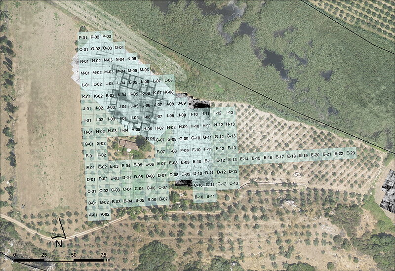
The suburban structures in the northwest of the city directly adjacent to the Roman harbor are geophysically particularly informative. Here a dense, multi-phase development and an irregular street grid emerges. In a research project organized as a dissertation the geophysical basic data must be evaluated and archaeologically interpreted. The analysis of the geoarchaeological results are also intended on a micro level. Based on these evaluations, a reconstruction of the city and its landscape will be attempted that will do justice to the complexity and dynamics of the settlement center of Ephesos.

Very little is known of the rural settlements in the immediate vicinity of Ephesos. Villages are mentioned in inscriptions but so far not one has been excavated. Additionally, there must have been numerous villas, namely both agricultural establishments as well as luxurious country estates of wealthy Ephesian citizens. A large villa 10,000 m2 in size was discovered with ground-penetrating radar 4 km west of the city. The layout follows the type of an Eckrisalit (pavilion) villa known from the northwestern provinces and is dated through surface finds to the 2nd/3rd century CE. A second villa was documented to the south east of Ephesos.
Furthermore, stray finds testify to numerous villages in the surroundings of the city as well as the adjacent valleys. However, their exploration is still at the beginning and until now has depended on random finds.