A survey project conducted in cooperation with the Ephorate of Antiquities in Achaia aims to record the structure of the city of Aigeira in greater detail. Previous research has so far concentrated mainly on individual public and religious buildings in discrete areas of the site. The current survey looks at the organisation and everyday life of the city, which covered almost 50 hectares in the Hellenistic-Roman period - a gap that is to be closed with the help of the survey. In a new diachronic study, the post-Mycenaean fortification walls are examined with special attention to chronology, expansion and the connection between architecture and landscape.
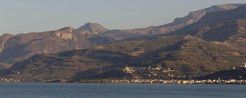

Aigeira was one of the few places in the coastal region of East Achaia with natural conditions that made permanent settlement possible. The stable bedrock was an important prerequisite for settlement activity in this highly earthquake-prone region. In addition, the location high above the sea allowed excellent long-distance visibility and thus the possibility to control coastal and inland routes. All this obviously outweighed the disadvantages of the steep terrain and the difficult supply of fresh water, as evidenced by the settlement activity that can be recorded at this site from the 6th millennium BC until the Middle Ages.
The survey examines the organisation of the ancient city over the long durée. A central question for understanding urban development is how the Archaic-Classical settlement was structured in comparison to the newly founded Hellenistic ›lower city‹. While little is known about the early city, it appears that the Hellenistic ›lower city‹ may have been laid out according to a uniform plan. This is suggested by the orientation of the antiquities still visible on the surface, which follow the cardinal points. Targeted surface surveys and geophysical investigations are intended to provide further insights into the building density, the network of streets and roads, and the location of residential and craft quarters and public squares.
An important basis for planning the urban survey is the evaluation of historical plans and aerial photographs. The comparison of modern topographic photographs shows that although the land division has changed only insignificantly in the last 50 years, in contrast to the 1950s and 1960s, tree planting, especially olive, dominate today. Since these fields are hardly ever ploughed, comparatively few surface finds are to be expected at the corresponding sites.
The first results of the survey were obtained from a conspicuously flat area measuring about 150 × 60 m, which has always been associated with a town square, possibly the central agora of the ancient city. Here, at the end of the 19th century, the Greek archaeologist Valerios Stais had already discovered parts of the Diocletian's maximum price edict, which was valid throughout the Roman Empire. The remains of a large rectangular structure - possibly a naiskos-like building or a large peristyle building - as well as a presumably late Roman spolia building are also clearly visible on the surface and in the geophysical analysis, The surface finds, including stone Doric and Ionic building elements and column drums, as well as terracotta fragments of lion's head spouts and Hellenistic and Roman fine pottery, also support the assumption that this was not a private but a public area.
In the upcoming campaigns, the survey will concentrate on the northern and western part of Hellenistic ›lower city‹, an area that is still referred to by the locals with the toponym "Spitia" (houses). Otto Walter, in 1925, had already suspected the residential quarters of the ancient city were here due to the numerous wall features visible on the surface.
The extraordinarily long period of settlement activity in Aigeira, ranging from the Late Neolithic to the modern period, offers favourable conditions for investigating the city's fortification systems in a diachronic study.
Aigeira has four fortification systems dating from the Mycenaean to the late or post-antique period. The focus of the project is on the fortifications of the post-Mycenaean period; the Mycenaean city walls are part of the research of W. Gauss. The conditions for the study are favourable, because Aigeira is not only one of the best preserved poleis of Achaia, but also has one of the longest settlement continuities in the area.
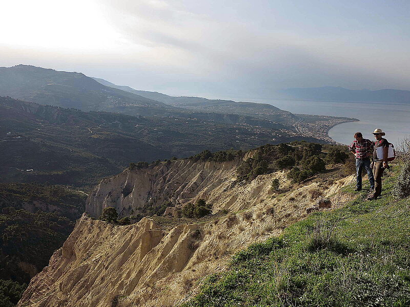
Aigeira's urban area is dominated by a double acropolis to the south and features steep cliffs on its east and west sides. The cliffs frame a gently sloping, terraced hillside. A narrow isthmos to the south divides, making it difficult to conquer but easy to defend. A series of small forts and towers, recently identified in the "Aigialeia Survey Project" of the Italian School of Archaeology at Athens, probably played an important role in defence and control of the communication routes.
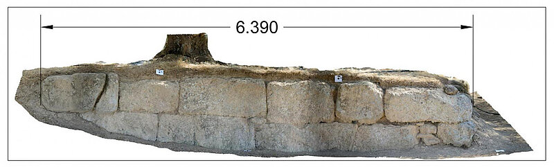
The Archaic fortification system covers an area of about 3.5 ha around the area of the acropolis and the upper town, but has so far been recorded in only a few places.
The largest ring of walls, which encloses about 50 ha of settlement area, was probably built in the Late Classical/Early Hellenistic period. It is particularly surprising that only the Late Classical/Hellenistic fortification was equipped with a few towers. While this is not unusual, it should be re-evaluated in light of the topography and historical context. A possible role in the design of the fortifications could also have been played by the Achaean League, of which Aigeira had been a member since the 5th century and then again since the early 3rd century. It is also conceivable that the expansion of the settlement was due to the influx of inhabitants from Aigai, who moved to Aigeira towards the middle of the 4th century BC because of the poor living conditions in their home town (Paus. 7, 25, 12; 8, 15, 9). This ring of walls was apparently not changed in post-Hellenistic times.
In any case, the latest fortification system makes no reference to older defences: it encompasses the western acropolis hill, which was an important settlement point from Mycenaean to Classical times. The purpose and dating of this fortification system have not yet been clarified; after a first review of the finds from older excavations, it is likely to be a late antique hilltop fortification.
In order to clarify these open questions, it is necessary to establish as precise a chronology of the fortifications as possible. The shape of the fortifications is to be reconstructed based on excavations at selected points and with the help of building research analyses.
since 09/2019
since 2016
