The research in Troesmis focuses on the settlement archaeological transformation processes from antiquity to the Middle Byzantine period. Using innovative methods such as motorised geophysical prospection, large-scale field surveys and geoarchaeological drilling, significant insights have been gained in recent years into the structure of the Roman legionary fortress and the adjoining civil settlement (canabae legionis and municipium). These investigations have made it possible for the first time to document an ancient centre on the lower Danube and a Byzantine settlement from the 10th to 12th centuries. They therefore make a significant contribution to understanding the historical development of this strategically important region.
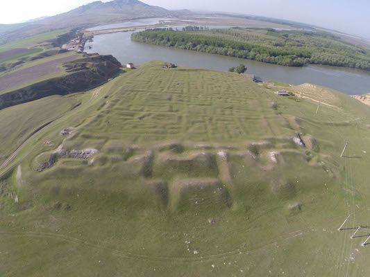
Significant progress was made using state-of-the-art geophysical methods, including magnetometry and ground-penetrating radar. Detailed plans of the legionary fortress and civilian settlement areas were created for the first time. Notable achievements include new insights into the structure of the Legio V Macedonica camp, with reconstructions of gates, towers, and internal buildings such as the valetudinarium (military hospital) and fabrica (workshop). The civilian settlement outside the camp reveals an organically developed road network and significant structures like bathhouses and temples. These findings highlight Troesmis‘ role as a key military and civilian hub on the Lower Danube and set new benchmarks for the study of Roman frontier settlements.
since 2010
