Over millennia, the Mediterranean divided and connected the civilizations living along its shores. Exchange of sought-after products was very likely the driving force for mankind to take to seafaring along its coasts in the first place. Since early times, Lebanon provided one of these desired products, i. e. timber that grew in abundance on its mountains – tall and strong enough for the construction of temples, palaces and ships. During the 2nd millennium BC (Middle and Late Bronze Ages) trade with the Eastern Mediterranean intensified to an international level, as we know from textual and archaeological evidence from regions outside Lebanon. For a long time the excavations at Byblos were our only Lebanese source of information concerning coastal contacts with other countries such as Egypt or Crete. While in the last fifty years in other regions of the Near East new discoveries provided loads of new data and evidence for that time period, in Lebanon archaeological investigations came to a complete standstill due to the civil war (1975‒1990). Thus, there are still large areas in this country, where we have hardly any knowledge about their past. One of these areas is the coastal region of Chekka situated north of Batroun and south of Tripolis.
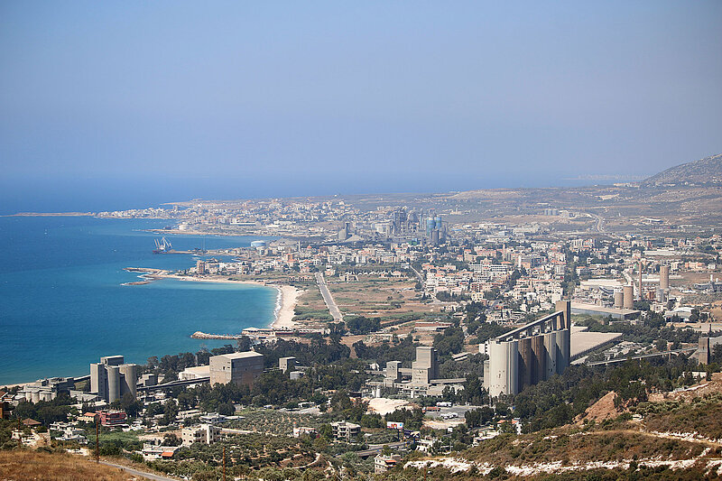
In a survey undertaken in summer 2016 by OREA in cooperation with Hermann Genz from the American University of Beirut (AUB) the potential of this area became evident. One of the main sites there is Tell Mirhan situated in the Chekka Bay directly on the shore of the Mediterranean. In Antiquity the tell was about 6 ha in size and thus comparable in its dimensions to Middle Bronze Age Byblos. Nowadays, the northern part of the tell has been destroyed by the constructions of a cement plant during the 1950ies and by modern houses. These destructions left a 34m long E‒W section through the tell, thus providing us with the opportunity to study the remains of a Middle Bronze Age fortification system, that once probably surrounded the whole tell. It is one of only four known in Lebanon. The material retrieved from this section showed clearly that the area was integrated into an international trading network with Egypt and Cyprus for nearly a millennium. A survey into the hinterland of the tell showed that the area was at least populated from the Chalcolithicum onwards. During this survey it became also evident that several archaeological sites have been destroyed in recent years by modern construction activities and newly planted olive groves.
The FWF project “Between Land and Sea” plans to investigate in the coming years the layout and the diachronic development of the settlement and its material culture by means of geophysical investigations and excavations on the tell. A thorough study of the fortification system shall provide new insights into the construction of these massive structures. To understand the potential of the site as a regional and supra-regional centre for production and trade various environmental studies will be conducted.
An intensive survey of the hinterland to the site shall help to understand the infrastructure, communication and trade system between the coast and the inland. We are planning to support our investigations by the means of airborne laser scanning – a technique that was never deployed in Lebanon before. In cooperation with forest engineers from the University of Natural Resources and Life Sciences Vienna (BOKU) we like to investigate the transport ways for timber in this area from their place of lumber in the mountains till their loading onto ships in the Chekka Bay.