Aquileia was founded in 181 BCE as a colonia with Latin right and plays a key role in the economic and political-military development of the northern provinces. The trade metropolis was the starting and end point of the Amber Road and the most important river harbor and trading location of the Regio X. Dynamic development processes of a city can often be best recognized along its perimeter as manifests itself in Aquileia on the basis of the expansion of the city limits from the center to the west as seen on the spatial and temporal sequence of Republican and imperial/late antique fortification systems. The settlement structures within and outside the fortifications illustrate the diachronic changes in function of the urban and suburban space.
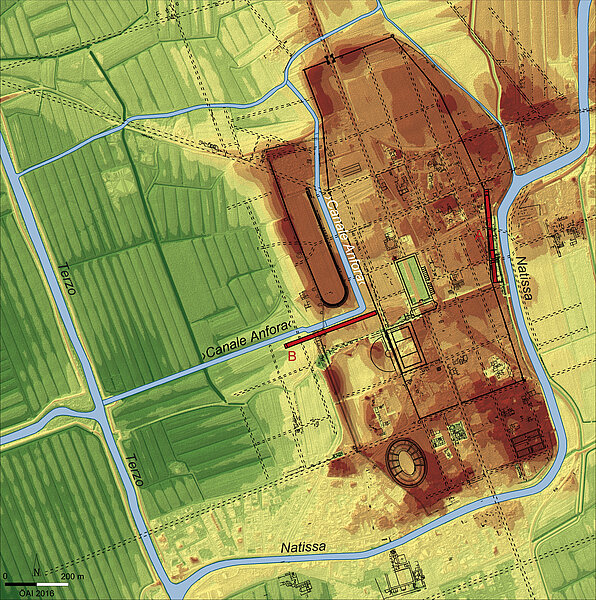
In reference to these transformation processes the diachronic development of the entire western city area and suburbs between the late antique city wall and the confluence of the »Canale Anfora« and the river Terzo is being studied. The geophysical survey results, including the data from metal detector and pottery surveys, and corings, explore this expansive research area and have led to important insights on the street grid, the waterways, and shipping docks.
The surveyed river and channel sections as well as the quay and harbor facilities shed new light on the development of the trade emporium. It had been assumed that the city only had one harbor (»east harbor«), but at least one additional river harbor (»west harbor«) has been identified along the »Canale Anfora« leading west up to the lagoon as well as a dense network of moles and warehouses along the navigable channels and rivers. It is likely that a large part of the trading in goods took place along the »Canale Anfora« up until the 3rd century CE since this directly ties into the network of waterways beyond the lagoon between the northern Italian regions X and VIII, Venetia and Aemilia. Based on the finds from the surveys, corings, as well as selective older excavations the newly discovered »west harbor« dates from the 1st century CE to the 3rd century CE; starting in the mid-3rd century the waterway began to partially silt up. The spectrum of survey findings again documents the function of Aquileia as a Roman trade center in an already »globalized« economic area of the Roman Empire.

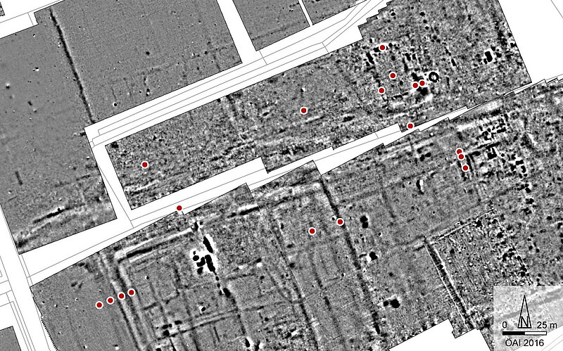
Under Constantine a stadium and a late antique city wall were built over a part of the »Canale Anfora«. All newly acquired prospection data on the monuments of the ludus of Aquileia are being interpreted within the framework of the urban research; this includes the so-called stadium as well as the amphitheater and theater. The geophysical measurements from along the western edge of the stadium verify that the city wall constructed there was fortified over a length of 327 m with a total of 11 towers at a distance of on average 30 m. The Tetrarchic fortification had alternating U-shaped and semi-circular towers; in the 5th and early 6th century CE they were reinforced with pentagonal towers. The youngest building measure can be seen in the construction of the mighty zig-zag wall when the city territory was reduced.