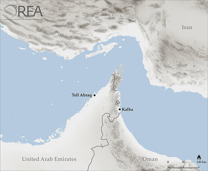
Across Arabia: Maritime Trading Networks in the Early Bronze Age Gulf Region
Within the 3rd millennium BC extended trading networks are evidenced for the first time, reaching from the eastern Mediterranean to the Indus region. The Early Bronze Age coastal settlement of Kalba (UAE, Sharjah) at the Gulf of Oman offers ideal conditions to start research on this topic, wherefore first systematic studies on-site are conducted.
Economic and geostrategic relevance of the region in the Early Bronze Age
Within the 3rd millennium BC, the Early Bronze Age, extended trading networks are evidenced for the first time, reaching from the eastern Mediterranean to the Indus region. Beside land routes, maritime and fluvial waterways seem to be essential for the function of these networks. This is evidenced by various sites situated at important nodes of the trading routes in which objects made of exotic raw material like, for instance, carnelian or lapis lazuli have been found. Therefore, it can be assumed that especially the region of Mesopotamia and the Gulf functioned as a mediator between east and west. In this context, the region of the south-eastern Arabian Peninsula with the Strait of Hormus offers, due to its geostrategic location, optimal conditions for nodes of these trading networks. Material studies conducted in this region indicate strong evidence of contacts between Mesopotamia and the Indus region. Besides objects, big tower constructions of the 3rd millennium BC in oases as well as in the coastal region suggest the integration of these sites in extended trading networks. However, apart from the site of Tell Abraq (UAE, Sharjah) situated at the western coast of the Gulf Region, little is known about the settlements of this period.
Potential of the pilot study at Kalba
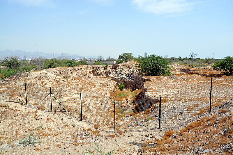
Therefore, the settlement of Kalba (UAE, Sharjah), situated in the alluvial plain in the coastal region of the Gulf of Oman holds great potential for further research on the Arabian Peninsula. Apart from occupation layers of the 2nd and 1st millennia BC, Early Bronze Age structures, like the remains of a massive tower construction as well as tombs in the vicinity of the site have been attested during investigations in the 1990s. However, the questions of the dimension of the site and its geomorphological situation have been left open, due to the small proportion of the excavated area. Consequently, systematic investigations of the settlement of Kalba, starting with basic geophysical analyses, are still lacking. Especially geophysics offer a great potential for an elementary assessment of the settlement’s function as well as its position within the framework of 3rd millennium BC trading networks.
Basic geoarchaeological research and visualization of the Cultural Heritage at Kalba
Geologically, the vicinity of Kalba is influenced by the Semail Ophiolithe complex, situated in the west of the settlement, which resulted from an ocean-continent collision in the late cretaceous. Thus, the coastal region of the Gulf of Oman is characterized by maritime and alluvial sediments consisting superficially of igneous rocks, which are transported from seasonal aquiferous Wadis of the western mountains.
During a one-month pilot study several objectives should be pursued as a basis for future research. In this context, it is crucial to conduct a systematic evaluation and recording of the geographic-geological situation of the site. This includes the detailed topographical documentation of Kalba by a drone, which is mandatory for further analyses and research with the help of geographic information systems (GIS). The obtained data offers the possibility of 3D-modeling of the site as well as the scientific results by ‘Structure for Motion technique’ (SfM). Beside the detailed documentation, these data also constitute the basis for an ensuing visualization of the Cultural Heritage at the site of Kalba. As shown by the excavations in the 1990s, nowadays large parts of the settlement are covered by sediments, as a result of which the extension of the settlement as well as the geomorphological conditions of the underground are completely unclear. To clarify these essential questions for future investigations, a combination of geophysical analyses (geomagnetic & georadar) will be applied. These methods are used to reveal details about the geological conditions as well as the spatial dimensions of the settlement and, moreover, indications about still covered archaeological structures.
The results of these first and fundamental geophysical analyses of the site of Kalba will be taken to conduct a small-scale trial excavation. Based on the stratigraphical evidence and the finds, a more detailed spatial assessment of the settlement should be possible.
Objective of the pilot study at Kalba
On the one hand, the aim of the pilot study at Kalba is to obtain data of the geomorphology and the settlement dimensions with the help of geophysical analytical methods; on the other hand, the trial excavation should provide more detailed information on the Early Bronze Age and possibly earlier remains of the site.
Presented Papers
Presented Papers
- Ch. Schwall – S. A. Jasim, Revisiting Kalba: new investigations at an Bronze Age coastal site at the Gulf of Oman (Emirate of Sharjah), American Schools of Oriental Research Annual Meeting 2019, 20.-23. November 2019, San Diego (CA), USA (23.11.2019).
- Ch. Schwall – S. A. Jasim, Assessing Kalba: new fieldwork at the Bronze Age coastal site Kalba at the Gulf of Oman (Emirate of Sharjah, UAE), Seminar for Arabian Studies of the British Foundation for the Study of Arabia (BFSA), 11–13 July 2019, Leiden University (12.07.2019).
- Ch. Schwall – M. Börner – N. Mittermair, New Investigations at the Bronze Age Site of Kalba: Preliminary Results and Future Perspectives, Sharjah Archaeology Authority (SAA), Sharjah, United Arab Emirates (31.01.2019).