Street View Imagery (SVI) represents a globally available data source containing a wealth of information regarding public spaces, the functional use of ground-floor zones, and architectural structures. In recent years, the analysis of SVI data, largely dominated by Google Street View, has seen exponential growth. Previous analyses, ranging from surveying building structures and mapping graffiti to analyzing vacancies in single-family homes, suggest that these data hold significant potential for urban research. However, the systematic recording and analysis of ground-floor zones remains a distinct research gap.
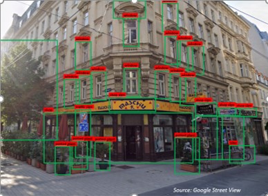
What data does this image contain? How can it be used for urban research?
(Google Street View)
The “MOSAIK” project aims to identify and analyze micro-scale socio-economic structures and dynamics within Vienna’s ground-floor zones. This is achieved using AI-based methods applied to image data (SVI and aerial photography). As part of this FFG-funded project, the team works in close cooperation with the geospatial company WIGEO GIS.
The project seeks to develop a robust and scalable data infrastructure that serves as a foundation for micro-level analysis (individual buildings). Using machine learning models, the project will identify building characteristics, design elements in public spaces, and specific ground-floor uses. To achieve this, the team will first generate high-quality training datasets to train and validate various AI models. This methodological approach allows the analysis to scale from localized training sets to the entire urban area.
Initial analyses indicate that this data can provide vital, previously unavailable information for urban research, specifically regarding ground-floor usage and the physical condition of residential buildings. This opens up new quantitative avenues for research into gentrification, segregation, and social inequality.
January 1, 2026 – December 31, 2027
FFG / Bridge-Call