Urban blue infrastructure—rivers, lakes, fountains, water playgrounds, and other water elements—is increasingly recognized for its role in supporting health, well-being, and quality of life in cities. Beyond their ecological functions, these spaces provide cultural ecosystem services by offering opportunities for recreation, social interaction, and place attachment.
Despite these benefits, urban blue infrastructure is often underprioritized in planning. There is a growing need to better understand its functions within urban systems and to more systematically integrate it into local planning and design. This requires a transdisciplinary approach that brings together expertise and knowledge from multiple viewpoints, including academic and practice-oriented actors as well as citizens as the experts of their day-to-day environments.
The BLUEMAP research project, funded by the Anniversary Fund of the City of Vienna for the period of March 2024 to February 2025, focused on mapping and analyzing citizen knowledge on the accessibility, availability, and quality of urban blue infrastructure in Vienna.
The project pursued two key aims:
1) To contribute empirical insights to international academic discourse on the role of urban blue infrastructure in planning for healthy, livable, and climate-resilient cities.
2) To address local knowledge needs and support citizen engagement in urban planning processes in Vienna.
Both aims were addressed using digital participatory mapping tools, enabling residents to share their experiences and perceptions of blue spaces across the city.
To address the main research question — “How can place-based citizen knowledge on the availability and quality of urban blue infrastructure inform the development of nature-based solutions in urban contexts?” — the project piloted and tested digital participatory mapping tools through real-life citizen engagement processes in Vienna, focusing on planning issues related to urban blue infrastructure.
As a first step, potential case study areas were identified using data from the prior FWF-funded research project CURB – The COVID-19 Pandemic as a Disruptive Force for Urbanization. Geospatial analysis of the CURB data, specifically on perceived access to urban blue infrastructure in respondents’ neighborhoods, indicated that areas in the vicinity of the “Westgürtel” had the lowest perceived access. These areas were selected as potential case study locations.
In the second step, public actors involved in managing urban blue infrastructure in Vienna were interviewed to identify potential collaboration partners and current knowledge needs. As a result, two research collaborations were initiated, as detailed below.
The first of the two digital participatory mapping surveys was developed in collaboration with Gebietsbetreuung Stadterneuerung Südwest (gb*südwest), the district administration of Rudolfsheim-Fünfhaus (15th Viennese district), and the Viennese Klimateam.
During the co-design process with gb*südwest, the survey was shaped to focus on the role of urban blue infrastructure—and the lack thereof—in mitigating and adapting to urban heat. The aim of the survey was to gather place-based citizen knowledge about public spaces perceived as uncomfortably hot during summer heatwaves, as well as locations used for cooling in personal heat adaptation strategies. The survey was available in multiple languages and was widely promoted through the communication channels of the cooperation partners, including newsletters, the neighborhood newspaper, social media, and printed posters and flyers.
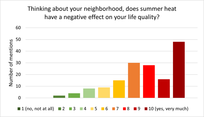
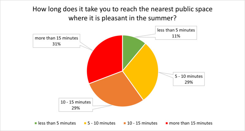
The survey had 219 respondents who mapped 2,060 locations across three mapping questions. Overall, the results suggest that heat negatively affects the perceived life quality among the study participants and across population groups. The majority of participants estimated heat waves to influence their life quality negatively or very negatively. Sixty percent of respondents estimated that they would need more than ten minutes to reach the closest public green space providing heat-mitigating benefits during heat waves, indicating that objective accessibility metrics may overestimate the availability of green spaces providing cooling in the neighborhood.
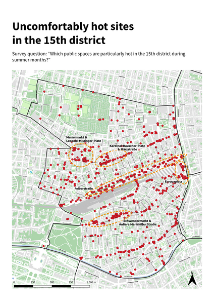
Respondent-mapped sites perceived as uncomfortably hot during heatwaves were primarily located along major traffic routes and commercial streets, in public open spaces with sealed surfaces and limited shade, as well as in parts of the traffic environment where pedestrians are exposed to heat with few opportunities for cooling (e.g., traffic lights, public transit stops, bridges). The most common reasons reported for the experienced heat were a high proportion of sealed surfaces (marked for 87% of sites), a lack of shade (70%), and a lack of trees (63%). The main clusters for sites perceived as uncomfortably hot during heatwaves were found around 1) Meiselmarkt and Leopold-Mistinger-Platz, 2) Kardinal-Rauscher-Platz and Märzstraße, 3) Felberstraße, 4) Europaplatz, and 5) Schwendermarkt and Äußere Mariahilfer Straße.
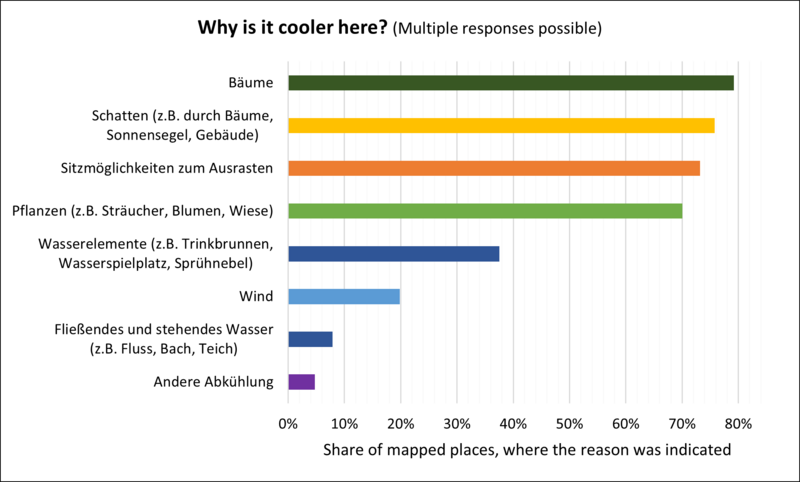
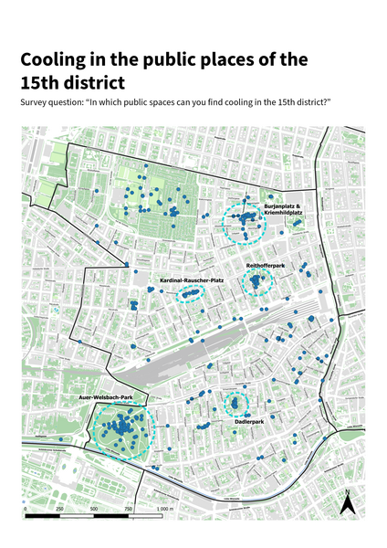
Cooling was found mostly in the public parks of the district, with clusters in 1) Auer-Welsbach-Park, 2) Dadlerpark, 3) Burjan- und Kriemhildplatz, 4) Reithofferpark, and 5) Kardinal-Rauscher-Platz. The presence of trees was the most common respondent-stated reason for the perceived cooling effect and was marked for 79% of sites with cooling benefits. It was followed by presence of shade (76%), seating (73%), and vegetation (70%). The presence of water features (e.g., drinking fountains, water playgrounds, and misting systems) was marked as a reason for the perceived cooling effect for 38% of sites.
The majority of respondents (56%) had not participated in urban or neighborhood planning processes prior to this survey. This result supports the notion that e-participation tools have potential to scale up public participation by involving residents who are not typically active in in-situ participation events.
More results on the survey are available in the survey report. The survey data can be accessed at the Austrian Social Science Data Archive AUSSDA (requiring institutional log in).
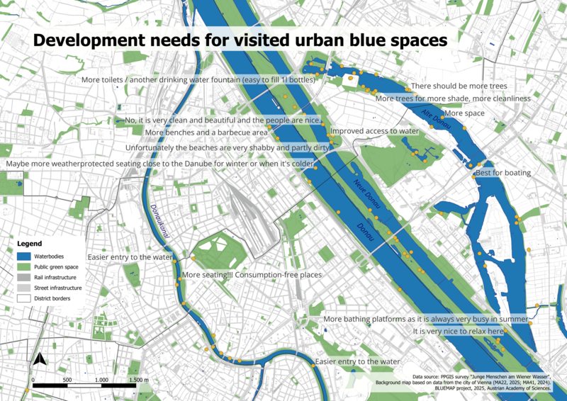
A second survey was developed in cooperation with Wiener Gesundheitsförderung – WiG, focusing on urban blue spaces and youth. Young people were chosen as the target group due to their frequent marginalization in urban planning processes, despite being potentially vulnerable and active users of public space. The aim was to identify which urban blue spaces are used by youth, how they use them, and what amenities and infrastructure they consider important or in need of improvement.
The survey was available in multiple languages and promoted through youth centers across Vienna. It was completed by 44 respondents, 60% of whom identified as female.
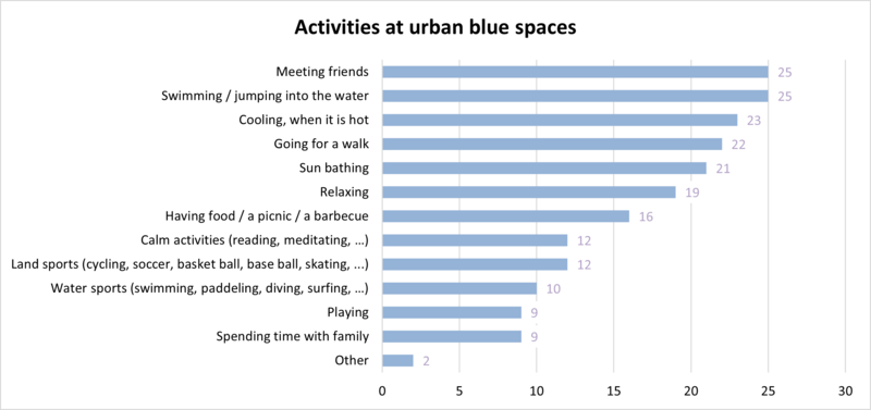
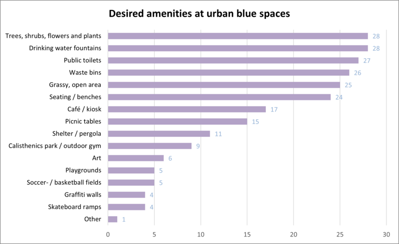
The results show that 77% of respondents visit urban blue spaces regularly (once or more per month), while only two percent reported never visiting such spaces. Seventy percent of respondents perceived blue spaces to be easily accessible. The most common activities included swimming and meeting friends, followed by cooling off, walking, sunbathing, and relaxing. Ninety-four percent of respondents associated being near water with positive emotions, 87% reported a sense of restoration, and 90% felt a connection to nature in these spaces. Key amenities identified as most important were trees, vegetation, drinking fountains, and seating, followed by public toilets, waste bins, and grassy areas.
Respondents saw the greatest need for additional water features in western Vienna. Among water features, misting systems were rated most positively, followed by drinking fountains, ponds, and open water surfaces. Ornamental fountains and water playgrounds were less favored among the respondents.
Overall, the survey highlights that urban blue spaces are important to youth for leisure, social interaction, and restoration. It also suggests that planning efforts would benefit from incorporating young people’s perspectives, as they are frequent users with valuable place-based knowledge.
More results on the survey can be found in the Factsheet (in German only).
1.03.2024 - 28.02.2025
The project is funded by The Anniversary Fund of the City of Vienna for the ÖAW.