Landscape and Cityscape: Analysis of a landscape in the Egyptian Delta
Tell el-Dabʿa/Avaris, the capital of the Hyksos, is located in the eastern Nile Delta along the Pelusian arm. Since the modern landscape is considerably different than in antiquity, the reconstruction of the ancient city and its integration into the original landscape is a fundamental aspect of the research at this site.
Location of the city and the hinterland
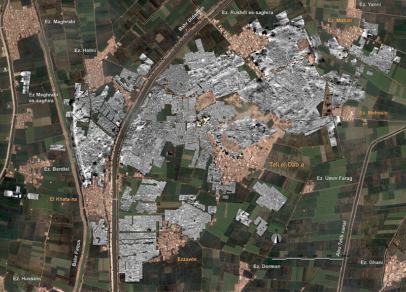
The find site of Tell el-Dabʿa is located in the northeastern Nile Delta in the modern province of Sharqeya. Ancient Avaris was situated along the Pelusian Nile arm, the eastern Delta arm, in a strategically important location at the starting point between the Egyptian Nile valley and the Middle East. The city covers an area of 260 ha and was one of the largest cities in the Middle East in the 2nd millennium BCE. The river system and the quays are a crucial factor for understanding how a city functioned in ancient Egypt because the Nile and its side arms were the main traffic routes and the most important means of transportation.
Aim of the project
The study of the landscape was an essential element of the research in Tell el-Dabʿa/Avaris long before the term ›landscape archaeology‹ became prominent in archaeology. The reconstruction of the ancient landscape was one of the main objectives of the studies at this find site because the modern Delta landscape differs greatly from the ancient one as a result of large-scale modifications in the second half of the 19th century.
Preliminary work
The reconstruction of the former landscape required one of the most extensive coring surveys in Egypt because the ancient channel and river system had almost completely disappeared: with a simple hand drill J. Dorner (Vienna) took more than 800 cores. The geological and archaeological evaluation of the cores led to one of the first reconstruction of the ancient river landscape and to an attempt at a historical-topographical map of the ancient city including a pre-digital terrain model.
Geophysical survey
In addition to the coring, the magnetic survey proved to be a very successful survey method; in Tell el-Dabʿa a caesium (C. Schweitzer) as well as a fluxgate magnetometer (T. Herbich) were used right from the start. The VES-resistivity sounding was another successful method.


Results
A complete plan of the city and its hinterland was created through the analyses using geophysical methods and the evaluation of satellite imagery (Google Earth and corona satellite images). The thorough analysis of this plan permits the identification of urban key areas, such as the administrative centers (Area R/III) or harbors (Area R/IV). An outstanding discovery was the hitherto unknown palatial complex of the Second Intermediate period in Area F/II. Through this work it will be possible to conduct precise archaeological excavations at nodal points and traffic lines of the city in the future.
Principal investigator
Cooperations
- Universität Lyon, UMR 5133 Archéorient
- CNRS
- Universität Straßburg UMR 7362
- Polnische Akademie der Wissenschaften und Universität Warschau
- Vienna Institute for Archaeological Science (VIAS)
Duration
since 2010
Funding
FWF [Projekt P25804]